Posts

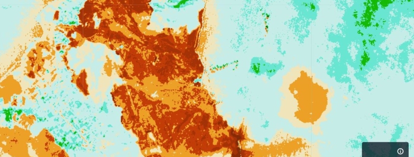
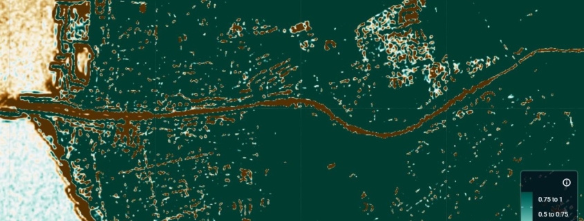
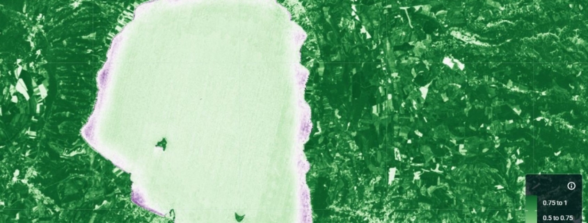
Chlorophyll concentration map (NDCI Index)

The NDCI index is used to assess the concentration of chlorophyll-a in water bodies.

Availability: Available

Data Type: raster

Delivery Method: API, Direct download

Compatible with: ArcGIS Enterprise, ArcGIS Online, ArcGIS Pro, QGIS

Piattaforms: Desktop, Web

System Requirements: None

Version: 1.0

Coverage Area: Italia

Data Format: Tiff, GeoTiff, .jpg, Excel, csv, .pdf

Sistema di riferimento: WGS 1984 UTM Zone 32N (EPSG: 32632)

Sources: Sentinel-2 Copernicus Programe

Burn area intensity map (NBRI Index)

The NBRI index is used to identify areas affected by fire and to measure the severity of the burn.

Availability: Available

Data Type: raster

Delivery Method: API, Direct download

Compatible with: ArcGIS Enterprise, ArcGIS Online, ArcGIS Pro, QGIS

Piattaforms: Desktop, Web

System Requirements: None

Version: 1.0

Coverage Area: Italia

Data Format: Tiff, GeoTiff, .jpg, Excel, csv, .pdf

Sistema di riferimento: WGS 1984 UTM Zone 32N (EPSG: 32632)

Sources: Sentinel-2 Copernicus Programe

Burn Area map (BAI Index)

The BAI index is used to identify areas affected by fire.

Availability: Available

Data Type: raster

Delivery Method: API, Direct download

Compatible with: ArcGIS Enterprise, ArcGIS Online, ArcGIS Pro, QGIS

Piattaforms: Desktop, Web

System Requirements: None

Version: 1.0

Coverage Area: Italia

Data Format: Tiff, GeoTiff, .jpg, Excel, csv, .pdf

Sistema di riferimento: WGS 1984 UTM Zone 32N (EPSG: 32632)

Sources: Sentinel-2 Copernicus Programe


Vegetation water content map (NDMI Index)

The NDMI index is used to detect the moisture level in plants by leveraging the spectral bands NIR (near-infrared) and SWIR (short-wave infrared). The formula is based on a band ratio: NDMI = (NIR – SWIR) / (NIR + SWIR)

Availability: Available

Data Type: raster

Delivery Method: API, Direct download

Compatible with: ArcGIS Enterprise, ArcGIS Online, ArcGIS Pro, QGIS

Piattaforms: Desktop, Web

System Requirements: None

Version: 1.0

Coverage Area: Italia

Data Format: Tiff, GeoTiff, .jpg, Excel, csv, .pdf

Sistema di riferimento: WGS 1984 UTM Zone 32N (EPSG: 32632)

Sources: Sentinel-2 Copernicus Programe

Water bodies map (NDWI Index)

The NDWI index is used to detect and analyze water bodies in a satellite image by leveraging the NIR (near-infrared) and GREEN (visible green) spectral bands.

Availability: Available

Data Type: raster

Delivery Method: API, Direct download

Compatible with: ArcGIS Enterprise, ArcGIS Online, ArcGIS Pro, QGIS

Piattaforms: Desktop, Web

System Requirements: None

Version: 1.0

Coverage Area: Italia

Data Format: Tiff, GeoTiff, .jpg, Excel, csv, .pdf

Sistema di riferimento: WGS 1984 UTM Zone 32N (EPSG: 32632)

Sources: Sentinel-2 Copernicus Programe

Biomass estimation map (RTVICore Index)

The RTVIcore index is a vegetation index used for estimating biomass.

Availability: Available

Data Type: raster

Delivery Method: API, Direct download

Compatible with: ArcGIS Enterprise, ArcGIS Online, ArcGIS Pro, QGIS

Piattaforms: Desktop, Web

System Requirements: None

Version: 1.0

Coverage Area: Italia

Data Format: Tiff, GeoTiff, .jpg, Excel, csv, .pdf

Sistema di riferimento: WGS 1984 UTM Zone 32N (EPSG: 32632)

Sources: Sentinel-2 Copernicus Programe

Health and density vegetation map (NDVI)

The NDVI index is a measure of vegetation vigor and can be used to easily distinguish green vegetation from bare soil.

Availability: Available

Data Type: raster

Delivery Method: API, Direct download

Compatible with: ArcGIS Enterprise, ArcGIS Online, ArcGIS Pro, QGIS

Piattaforms: Desktop, Web

System Requirements: None

Version: 1.0

Coverage Area: Italia

Data Format: Tiff, GeoTiff, .jpg, Excel, csv, .pdf

Sistema di riferimento: WGS 1984 UTM Zone 32N (EPSG: 32632)

Sources: Sentinel-2 Copernicus Programe

Settlement Heights (ANBH)

The spatial raster dataset represents the Average Net Building Height (ANBH) of built structures, calculated only on pixels with height values greater than 0 m, thus excluding non-built ground areas.

Availability: Available

Data Type: raster

Delivery Method: API, Direct download

Compatible with: ArcGIS Enterprise, ArcGIS Online, ArcGIS Pro, QGIS

Piattaforms: Desktop, Web

System Requirements: None

Version: 1.0

Coverage Area: Italia

Data Format: Tiff, GeoTiff, .jpg, Excel, csv, .pdf

Sistema di riferimento: WGS 1984 UTM Zone 32N (EPSG: 32632)

Sources: Sentinel-2 Copernicus Programe

Settlement Heights (AGHB)

It represents the Average Gross Building Height (AGBH) of buildings in meters, considering both built-up areas and empty spaces (ground) within the analysis cell. AGBH is therefore the average height calculated by taking into account the entire built volume of the structure, from ground level to the top of the buildings.

Availability: Available

Data Type: raster

Delivery Method: API, Direct download

Compatible with: ArcGIS Enterprise, ArcGIS Online, ArcGIS Pro, QGIS

Piattaforms: Desktop, Web

System Requirements: None

Version: 1.0

Coverage Area: Italia

Data Format: Tiff, GeoTiff, .jpg, Excel, csv, .pdf

Sistema di riferimento: WGS 1984 UTM Zone 32N (EPSG: 32632)

Sources: Sentinel-2 Copernicus Programe

Settlement Surface

The spatial raster dataset depicts the distribution of built-up surfaces, expressed as number of square metres.

Availability: Available

Data Type: raster

Delivery Method: API, Direct download

Compatible with: ArcGIS Enterprise, ArcGIS Online, ArcGIS Pro, QGIS

Piattaforms: Desktop, Web

System Requirements: None

Version: 1.0

Coverage Area: Italia

Data Format: Tiff, GeoTiff, .jpg, Excel, csv, .pdf

Sistema di riferimento: WGS 1984 UTM Zone 32N (EPSG: 32632)

Sources: Sentinel-2 Copernicus Programe